Wednesday, October 27, 2010

Operating on Fact

en·cy·clo·pe·di·a  [en-sahy-kluh-pee-dee-uh]       –noun
a book or set of books containing articles on various topics, usually in alphabetical arrangement, covering all branches of knowledge

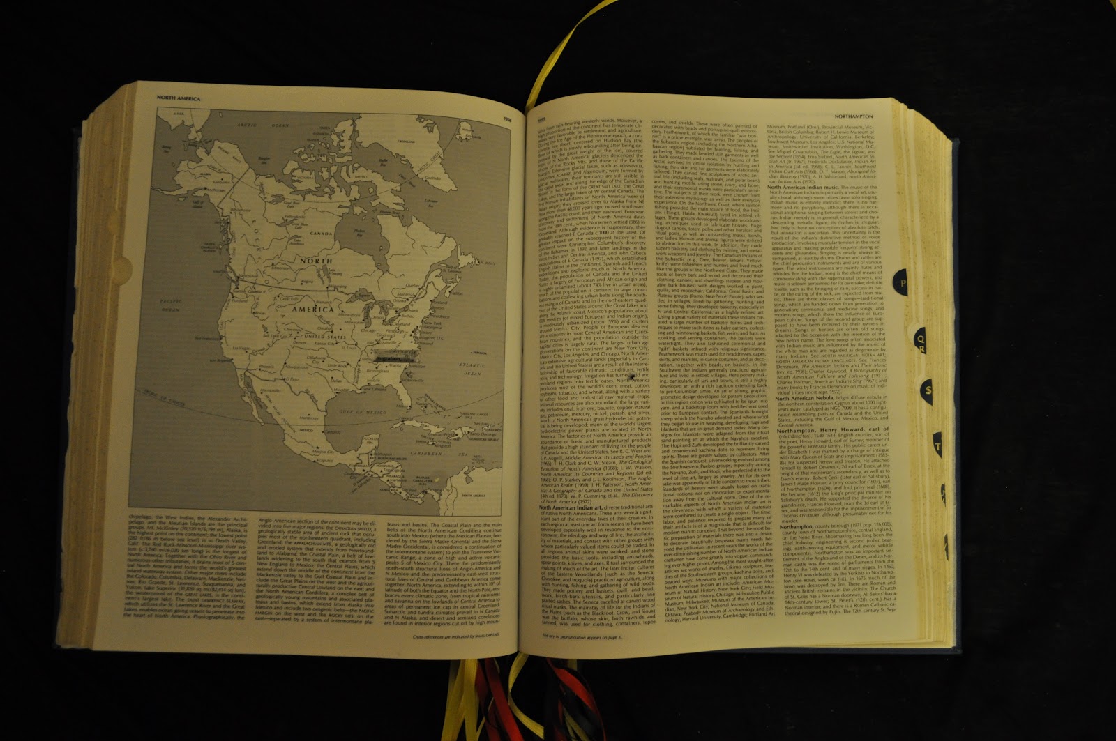
The encyclopedia acts as a concrete artifact which is altered to re-intrept so-called ‘factual’ information.   Through tracing, extracting, and plotting the book begins to operate as the thesis.  Operating within the encyclopedia question how history is documented and re-told.  While it can be argued that the encyclopedia is a book of facts or book of fiction, it is accepted as general knowledge of events, places, and people.  The encyclopedia is then a map in itself, documenting common knowledge to propel human cultures.  Using the academic and artistic references, each operation situates itself into the encyclopedia. 


MOVE I. re-tracing words_ [fill in the blanks]


printed law _______ life
government regulating ______ flow
hunting _____ legal american 
material marks home 
bubbles of idealization ____
masses ____ knowledge ____ war
coexistance ______ brown _____ banned
citizens _____ condition _______ reproduce
buildings _______ formality ______architecture

Reading across topics and information presented on a given page to read a second code of information that is being presented.  Questioning the words used to present facts.  


MOVE II.  mapping agency, (insert)
A new article is added in between map and map projection which defines the agency of mapping according to James Corner.  It references back to inserts Guy Debord, extract, field, and plotting. 

MOVE III.  frontier, (re-define)
Working off of the thesis’ lexicon of terms, a new explanation of frontier is inserted.  The previous explanation defines frontier in relation to the movement out west with example frontier as ‘the mining frontier’ ‘the fur trade frontier’ and ‘the gold frontier’.  The new definition defines the frontier as a boundary, a line of control which exists as a cultural understanding not as a physical boundary.  

MOVE IV.  tracing migrant labor (insert, overlay)
Three different explanations of migrant labor are inserted adjacent to the 1975 Encyclopedic explanation.  The other excerpts come from a the Oxford Companion to U.S. History (2001), the Columbia Encyclopedia (2008), and Wikipedia, (2010).  This move allows one to trace how history redefines and proves how presented facts are actually interpretations that are always changing.  

MOVE V. framing migration (cut)
Through removing information the migration is now able to be viewed within the context of North America, the most notable content of migration.  


MOVE VI. realign the railroad (cut)
Cutting through the pages allow for a new connection between topics.  Instance such as the ‘underground railroad’ and ‘railroad’ which self reference each other in their explanations can now be viewed simultaneously as one is always informing the other.  Trail and trace can also be viewed within this move as thesis looks at tracing these historical events and the effect of trails.  

MOVE VII. trail (re-define)
Previously explained as a city, trail is not understood in the terms of the thesis as a residue left behind. They are patterns of movement of the people and animals which have left a mark on the land.  This definition references King Peter’s ‘Seven Trails West’, Pereguine’s ‘Ancient Human Migrations’ and Nash Smith’s ‘Virgin Land’.

MOVE VIII. what is war? (re-arrange)
Through cutting up an re-arranging the text explaining ‘war’ you can no longer understand what it is and why it occurs. It forces the reader to define for themselves what war is.

MOVE IX. concealing government (cover-up)
All you need to know about the government is that it has power over you.  The rest of the explanation is covered with black tape and only reveals the word power.  

MOVE X. World War II (lettering)
The narratives of the events of WWII are more valuable than the description of the who won what battles and what countries fought whom.  Therefore inserted over the explanation are excerpts from a trail of letters during the war. Choosing to remember the narrative has significance and implications in collective interpretation and memory.  

Tuesday, October 19, 2010

Shifting Scenes


Monumental shifts in traditional frameworks of thought and theory lead to the creation of new paradigms.  Operating across history, architectural periods, and text our work questions reality and fiction.  The scale moves from the most concrete reality of the existence of a site to the shift in the author’s role in (re)defining the site, to the representation of a fictional narrative through image or text.  Lines connect from the reality-fiction scale to methods of narrative and historical moments.  When these lines intersect a fictional text is generated which operates in the narrative method and time period being traced.

Trailing Signs

Architects such as Fernando Romero and Teddy Cruz have published architectural proposals that challenge the current state of the U.S-Mexico Border. Cruz’ practice challenges the aesthetics and qualities of life across both sides, arguing for an infiltration of the density existent in the Mexican barrios into suburban America. Fernando Romero from LAR re-appropriates the 2,000 mile long border, dissecting the political and social issues then projecting new futures. In his book HyperBorder he calls attention to the Border as a territory with the potential to be revived, rather than ignored. He recognizes the border’s importance and ability to alter both countries’ future, as Mexico and the United States are already heavily interdependent. Romero projects potential futures interventions which could alter, and arguably improve, the border as a megalopolis of cultural, social, and economic exchange. My position stands somewhat aside these two architects, as my interests lie along the U.S.-Mexico border. However, I am not interested in finding a solution or ultimate proposal to the very complex, heated, and layered political issues between both countries. What is important however is the current state of movement across the line. People, goods, and services are in a continuous flow North. There are two chapters to this story: Navigating Landscapes and Residual Traces.


Navigating Landscapes

Trailing Signs situates the movement and navigation along trails within a broader historical story. An estimated half a million migrants walk along the migrant trails in southern Arizona, traveling in groups with a coyote leading them through the desert. For the coyote there is no GPS or map to tell them where to go, it is all about memory and reading the land. Its takes a certain level of knowledge to be able to see. This continual bed of knowledge of the landscape and the trail network exists in the collective memory. This collective memory is the catalyst for the migration to occur. It is only through the previous experience of the place that the guide then knows where to navigate. It is a continual process of reading the land and recalling memories of place. Whether they notice the smell, the dense mesquite, a certain tree, or the shape of the mountains it is all linked to memories of the land.

Residual Traces

This migration pattern sits within a historical context of humans migrating and crossing frontiers, particularly in America. The trails are a residue left behind. They are patterns of movement and traces that have an alternate effect on the land. The traces can be viewed in relation to other historical trails: The Oregon Trail, The Mormon Trail, The Underground Railroad. Arizona’s Migrant trails will also be remembered in the collective history of politically charged territories. The Underground Railroad’s quilts are a collection of waypoints, which aided in navigation, but still had existence after the historical event, hence acting as traces from the past.


Through the act of layering multiple agents, trails, networks and catalysts the work digests multiple data and patterns into new systems of organization. Working along side Edward Tufte and James Corner the maps develop new visual connections across cultural, social, and statistical patterns. The collection of mappings becomes a living three-dimensional object, as movement is in a continual state of flux yet always referencing the past. The historical will always be present in the mapping of the current. Layers of political, social, and urban infrastructure are connected to the historical migrations of people, goods, and services along the networks of roads, rail, and rivers. The work takes into account political policies such as NAFTA, as a control of movement across the two countries.

The collection of maps is stored in a book, along with collected research and data trails. The maps sit between a written historical narrative of trailing and a projective architectural scenario which exploits the systems revealed by the mappings.

Friday, October 8, 2010

Wear/Whereabouts

The site exists in a lineage of America's history of forging new ground and crossing frontiers.  The memory of place exists as the operational site.  For the coyote there is no gps or map to tell them where to go, it is all about memory and reading the land.  Its takes a certain level of knowledge to be able to see.  This continual bed of knowledge of the landscape and the trail network exists in the collective memory.  This collective memory is the catalyst for the migration to occur.  It is only through the previous experience of the place that the guide then knows how to navigate.  It is a continual process of reading the land and recalling memories of place.  Whether they notice the smell, the dense mesquite, a certain tree, or the shape of the mountains it is all linked to memories of the land.  

This network of migrant trails is a residue left behind.  There are patterns of movement and traces which have an alternate effect on the land. The traces can be viewed in relation to other historical trails: The Oregon Trail, The Mormon Trail, The Underground Railroad.  Arizona's Migrant trails will also be remembered in the collective history of politically charged territories.  

There are two chapters to my story:  Navigating Landscapes and Residual Traces.  

Wednesday, October 6, 2010

Site as Thesis

Site_ The site no longer exists as a three-dimensional landscape, rather it is an occupation of memory.  Site is a continually evolving memory of experience, an alternate, reconstructed reality.  The memory is the instance which continues to be activated and recalled- not the topography lines of the changing land.  On the trails the terrain is rough and always changing. Individuals are no longer occupying merely the immediate visceral space, but their mental reconstruction of space.  For the guide a series of moments exist where memory is relied on, the site becomes the immediate view, the smell, the pattern of vegetation.  The walkers are going through the motions along a mountain trail, but their thoughts and memories are what keeps them moving and are what are occupying their minds.  The memory becomes the site for continual growth.  The knowledge of the guides is not documented in a map or special book which they carry with them.  The migrant trail infrastructure relies solely on the memory of place as the continual path of movement. Each walk north is different every time as following the same path is impossible without a gps.  The agents rely on the surrounding atmosphere, the sun and mountains, to point them in the right direction.  The experience is not one of a singular place rather a journey of the memory through time and space.

Tuesday, October 5, 2010

Border Wars-Nogales: City Under Siege

Constitution Free Zone


  • Normally under the Fourth Amendment of the U.S. Constitution, the American people are not generally subject to random and arbitrary stops and searches. 
  • The border, however, has always been an exception.  There, the longstanding view is that the normal rules do not apply.  For example the authorities do not need a warrant or probable cause to conduct a “routine search.” 
  • But what is “the border”?  According to the government, it  is a 100-mile wide strip that wraps around the “external boundary” of the United States
  • TWO-THIRDS of the United States’ population lives within this Constitution-free or Constitution-lite Zone.   That’s 197.4 million people who live within 100 miles of the US land and coastal borders. 
  • This illegitimate expansion of the extraordinary powers of agents at the border is also part of a general trend we have seen over the past 8 years of an untrammeled, heedless expansion of police and national security powers 

2010 Migrant Deaths in the Sonoran Desert

I just received this updated map of Migrant's Deaths in the Sonoran Desert along the Arizona-Mexico Border for 2010.  You can see the increasing deaths in the Tohono O'odham Nation.  The indian reservation is populated with migrant trails, and despite the deaths occurring on their land they won't allow humanitarian groups to drop water anywhere on the reservation.  In general they view that the water encourages more migrants to travel across their land. 

Immigrant Deaths allocated by Border Patrol Sector
provided by the Arizona Daily Star

The Tell Tale Trade [trailing networks]

Emigrant Trails
With my interest in the current Migrant Trails in southern Arizona, I am also connecting to a larger network of US history and our continually shifting population migrating across our own frontiers. The working migrant trail builds upon the history of other trails such as the Oregon Trail and the Mormon Trail.  


The Emigrant Trail is the classification or 'academic name' collectively applied to the easternmost common stretches of the northern networks of overland wagon trails throughout the near American West, used by emigrants from the eastern United States to settle lands west of the Sierra Nevada  and Rocky Mountains during the overland migrations in the middle and later 19th century.
For the emigrants, there was no fence to cross rather they were faced with crossing the frontier filled with mountain ranges and rough terrain.  


Oregon Trail (from the 1830s
Mormon Trail (from 1846), 
California Trail (from 1841)


The trail network has become embedded in the folklore of the United States as one of the significant influences that have shaped the content and character of the nation. The remains of many trail ruts can be observed in scattered locations throughout 
arid parts of the American West. Travelers may loosely follow various routes of the trail network on modern highways through the use of byway signs across the western states.
Up to 50,000 people, or one-tenth of the emigrants who attempted the crossing, died during the trip, most from infectious disease such as cholera, spread by poor sanitation. Hostile confrontations with Native Americans' defending their homelands, although often feared by the emigrants, were comparatively rare. Most emigrants traveled in large parties or "trains" of up to several hundred wagons, usually led by an experienced guide.

Sunday, October 3, 2010

Temporary Migrant Housing & Tunnel Infrastructure

Bryan Finoki of the blog SUPTOPIA looks into developing migrant farm worker housing as a new public infrastructure.  

Digging Into America: Migrant Tunnels, the new underground railroad 
"As you may or may not know Nogales, Arizona has quickly become the border tunnel capital of North America, as in illegal cross-border tunnel, at least as far as the U.S. government can tell. The latest numbers according to a NORTHCOM Task Force briefing that was apparently secretly leaked over the web just weeks ago, indicate between 1990 and November 2008, 93 cross-border tunnels were discovered, 35 of which were in California, 57 in Arizona, and 1 in Washington State" _subtopia
Nogales,US-Nogales,Mexico

Tunnel Entrance
"The watershed infrastructure and all its subset tunnels that wander under Nogales on both sides of the border are so vast perhaps the only way to truly gage the number of secret unaccounted-for passages that poke, spoke, and meander through it would be to airlift the entire structure (at the core two parallel concrete tunnels roughly fifteen feet wide and several miles long), scooping and dislodging it and plenty of surrounding earth (houses, city sewage tunnels and all) from its site fixed under the border, and dunking into some sort of nearby tank the size of at least twenty square city blocks filled with liquid foam core, then to delicately remove the infill tendrils later and see what extracted void sculpture you might be able to use to extrapolate a visualization of the smaller informal tunnels that violate the whole thing."  _subtopia

I'm itching to look into this tunnel infrastructure as well as another piece of the migrant trail